Lefever and Ard tracts - Early 19th Century, Wayne County, Kentucky
Jeffrey La Favre - jlafavre@gmail.com
See deed information below the map.
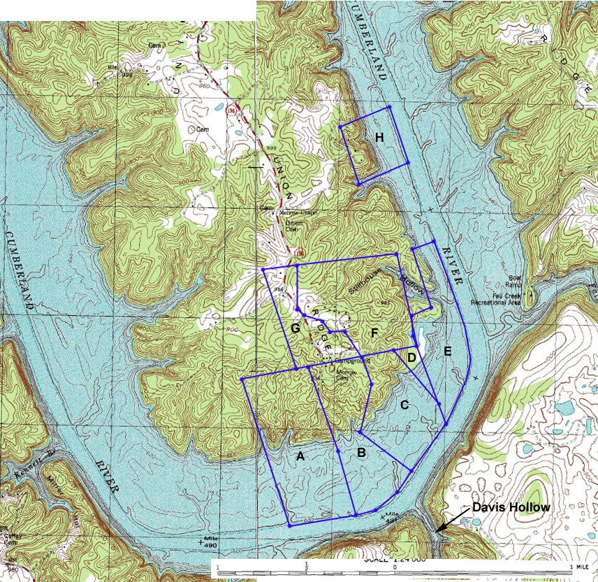
Tract E - David Lefever - 105 acres - Grants South of Green River, survey #6477, surveyed for Jacob Lefever on 25 JAN 1804, in Adair County [later Wayne County] Kentucky, by virtue of court certificate #42 granted by the County of Green in June 1801. Tract was assigned by Jacob Lefever to his brother, David Lefever, who obtained a grant for the land from Kentucky on 4 JAN 1811. Chain carriers for the survey were Jacob Leafever and John Davis and marker was Jacob Leafevers Sr. [probably Abraham Lefever Sr. (II)]. Beginning on the north side of the Cumberland River at a sugar tree, corner of military survey on the bank of the River thence with the line; N 34 W 170 poles to a black walnut; N 16 W 38 poles to a white oak and beech; N 54 E 38 poles to two buckeyes; N 32 W 112 poles to two buckeyes; N 55 E 40 poles to a sugar tree on the Banks of the River, thence down the meanders of the River to the beginning.
Tract C - Thomas Wilson - 132 acres - Wayne County, KY Deed Book B p. 135 - 139 - Indenture of 5 JAN 1814, James Dougherty & Hannah, his wife to Thomas Wilson, all of Wayne County, KY, for $300 - part of a survey of 500 acres granted to James Dougherty from James Colemen (in 1813) - north side of Cumberland River - Beginning at a sycamore and maple; N 61 W 112 poles to a sugar tree, stake between an ironwood and dogwood; N 11 E 97 poles to two ashes growing together; N 23 W 62 poles to two sugar trees & a small beech on Dougherty's line of S 70 W and with said line; N 70 E 98 poles to a stake agreed upon between James Dougherty and David Lefevers on the military line and with the same; S 22 E 150 poles to the military corner a sugar tree & hackberry on the River Bank; thence down the River binding thereon 100 poles to the beginning. Signed James Dougherty and Hannah Dougherty.
Tract D - David Lefever - 20 1/2 acres - Wayne County, KY Deed Book B p. 491 - 492 - Indenture of 28 OCT 1818, Thomas Wilson of Crawford, IL to David Lefevers of Wayne County, KY, for $100 - north side of Cumberland River - Beginning at a large red oak; N 42 W 132 poles to a hickory and small beech on said Wilson's north line; N 70 E with said line 42 poles to a bunch of white walnuts; S 22 E 112 poles to the beginning [note: this tract was cut from Wilson's 132 acre tract above]
Tract F - David Lefever - 100 acres - Wayne County, KY Deed Book D p. 287 - Indenture of 24 OCT 1826, John L. Dibrell to David Lefever, both of Wayne County, KY, for $300 - tract of land on the north side of Cumberland River, containing by supposition 100 acres, part of a 400 acre survey surveyed by Thomas Cameals heirs to said Dibrell - Beginning at a walnut on Lefevers line field on the military line running; S 70 W 100 poles to an ash thence; N 43 W 57 poles to a beech at the fork of a path thence; S 73 W 30 poles to a poplar thence; N 40 W 24 poles to two sourwoods thence; N 84 W 28 poles to a poplar thence; N 70 W 26 poles to a dogwood on the road thence; N 7 W with the road 8 poles [should be 80 poles] to a poplar on the military line thence with the military line; N 74 E 180 poles to the military corner thence; S 28 E with the military line 196 poles to the beginning. Signed Jn. L. Dilbrell
Tract H - Reuben Ard - 100 acres - Wayne County, KY Deed Book D p. 408 - 409 - Indenture of OCT 1827, Benjamin Gholson and Polly, his wife, of Pulaski County, KY to Reuben Ard of Wayne County, KY, for $250 - Beginning at a beech on the north bank of Cumberland River at the mouth of a branch, running up the branch; S 60 W 100 poles to a gum and poplar; N 25 W 100 poles to a white oak and sugar tree; N 60 E 100 poles to a beech and sugar on the Bank of the River, thence down the River; S 25 E 160 poles to the beginning. Signed B. Gholson.
Tract A - John Dougherty - 96? acres - Wayne County, KY Deed Book B p. 132 - Indenture of 5 JAN 1814, James Dougherty and Hannah, his wife, to John Dougherty, all of Wayne County, KY, 96 [probably should be 196] acres part of 500 acres granted to the said James Dougherty by James Coleman the __ day of __ 1813 - on north side of Cumberland River and marked and bounded as follows - Beginning at two elms on the north bank of Cumberland River and running; N 19 W 120 poles to three small beeches; N 21 W 170 poles to two poplars on James Dougherty's line of S 70 W and with said line; S 70 W 146 poles to James Dougherty's corner then; S 28 E 280 poles to two elms and a maple at the mouth of Wasons? Branch, thence up the River bending thence N 72 E 122 poles to the beginning.
Tract B - Benjamin Gholson - 150 acres - Wayne County, KY Deed Book B p. 134 - Indenture of 7 JAN 1814, James Dougherty and Hannah his wife, John, William and George Dougherty to Benjamin Gholson, all of Wayne County, KY - 150 acres part of 500 acres granted James Dougherty from James Coleman - on the north side of Cumberland River - Beginning at two small elms on the bank of the River, John Dougherty's corner and a dividing line between Gholson and Dougherty; N 19 W 120 poles to a double poplar John Dougherty's corner [then there appears to be a line missing or missed during transcription: N 21 W 170 poles to two poplars on] James Dougherty's line of S 70 W and with said line; N 70 E 100 poles to two sugar trees and a small beech on said line and Thomas Wilson's corner and with Wilson's line; S 23 E 62 poles to two ashes growing together; S 11 W 97 poles to a sugar tree licks between a sourwood and dogwood; S 61 E 112 poles to a sycamore and maple on the River Bank, thence down the River bending thereon S 25 W 46 poles S 40 W 52 poles S 67 W 36 poles to the beginning.
Tract G - Thomas Wilson - 110 acres [not plotted] and 80 acres - Wayne County, KY Deed Book D p. 237 - 238 - Indenture of 25 APR 1826, John L. Dibrill of Wayne County, KY to Thomas Wilson of Edgar County, IL, for $500 - north side of Cumberland River, 110 acres part of a 490 acre tract conveyed by John Chriman commissioned by Wayne Circuit Court - Beginning on Dibrills beginning corner at a poplar and hickory; S 70 E with Dougherty's line 80 poles to a black oak; N 30 W 220 poles; S 74 W 80 poles [should be N 74 W] to Dibrells corner a post oak and iron wood; S 30 E with Dibrells 224 poles to the beginning - also another piece containing 80 acres - Beginning at Lefevers corner an ash; N 45 W 57 poles to a beech; S 75 [W] 30 poles to a poplar; N 40 W 24 poles to a poplar; N 84 W 28 poles to a poplar; N 70 W 26 poles to a sourwood on the road, N 7 W 80 poles with the road to a poplar on the military line at figure 12 then with the military line S 74 W 64 poles to Burnham's corner then with Burnham's line; S 30 E 220 poles to Burnham's corner a black oak; N 70 E 120 poles to the beginning. - Signed John L. Dibrell.
Note for David Lefever tracts: the 100 acre, 105 acre and 20 1/2 acre tracts were sold 21 OCT 1842 to Solomon E. Tuttle (Wayne County, KY Deed Book J p. 200 - 201).
page last updated August 11, 2009